

 Home
HomeHow to streamline mapping with DeepSeek AI & QGIS in 2025? A complete guide
Artificial Intelligence is transforming geospatial workflows, bringing new levels of efficiency and insight. This article explores the practical integration of DeepSeek AI with QGIS, the powerful open-source Geographic Information System. Learn how this combination streamlines surveying and mapping, making advanced techniques more accessible for professionals and hobbyists. By leveraging DeepSeek AI's intelligent automation alongside QGIS's robust toolkit, users can achieve remarkable precision and productivity in their spatial projects.
Key Points
DeepSeek AI delivers AI-assisted mapping capabilities directly within QGIS.
QGIS is a comprehensive, free, and open-source Geographic Information System.
Integrating DeepSeek AI simplifies and accelerates complex mapping workflows.
The JSON Eater plugin is essential for processing data from DeepSeek AI.
Users can generate custom GeoJSON Python code tailored to their queries using DeepSeek AI.
Base maps can be added automatically through executed Python scripts.
Effective symbolization in QGIS significantly improves map clarity and visual impact.
Integrating DeepSeek AI for Mapping in QGIS
What is QGIS and Why Use It?
QGIS is a premier open-source Geographic Information System renowned for its power and flexibility.
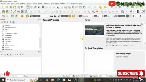
Its accessibility and extensive capabilities have made it the go-to choice for surveyors, cartographers, and researchers worldwide. Being free eliminates cost barriers and fosters widespread use. Its modular plugin architecture lets users customize the platform for specialized tasks, enhancing its versatility. A vibrant, active community provides ample support and learning resources for all experience levels. Regular updates ensure QGIS stays at the cutting edge of geospatial innovation.
QGIS offers a comprehensive suite of tools for mapping and spatial analysis, including:
- Robust handling of vector and raster data formats
- A vast library of geoprocessing algorithms
- Advanced cartographic design and layout tools
- Extensible functionality through a rich ecosystem of plugins
These strengths, combined with its open-source philosophy, make QGIS the perfect foundation for integrating AI-powered solutions like DeepSeek AI.
Unveiling DeepSeek AI: AI-Powered Mapping Assistant
DeepSeek AI is a cutting-edge application designed to automate and enhance mapping processes. It uses artificial intelligence to handle tasks like data extraction, feature identification, and map generation. Integrating it with QGIS unlocks superior efficiency and accuracy for geospatial projects. It can produce custom GeoJSON Python code based on user prompts, allowing for targeted data extraction and visualization within QGIS. A key benefit is its user-friendly design, which lowers the technical barrier to entry.
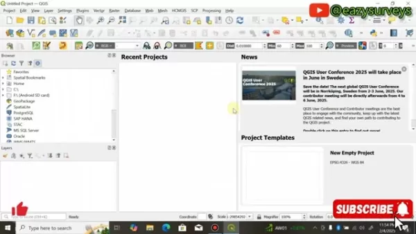
At its core, DeepSeek AI functions as an intelligent partner, interpreting user requests and delivering bespoke solutions. For instance, a user can ask it to map all major U.S. airports, and the AI will produce the precise Python code to extract and display that data in QGIS.
How to install the JSON Eater Plugin: Essential for DeepSeek AI Integration
A critical prerequisite for using DeepSeek AI is installing the JSON Eater plugin. This plugin allows QGIS to interpret and process the GeoJSON Python code generated by the AI.
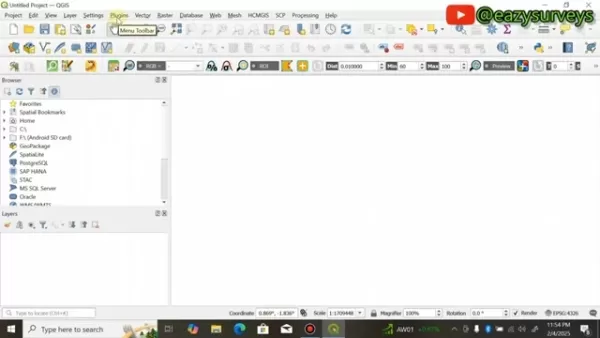
Follow these steps to install the JSON Eater plugin:
- Open QGIS.
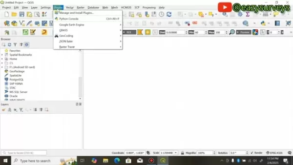
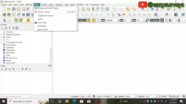
- Go to the 'Plugins' menu.
- Select 'Manage and Install Plugins...'.
- In the 'All' tab, search for 'JSON Eater'.
- Click the 'Install Plugin' button.
Note: A stable internet connection is required during installation.
The JSON Eater plugin acts as a vital bridge, translating the AI-generated code into a format QGIS can understand and display. It is free to use, and its absence would severely limit the integration between DeepSeek AI and QGIS.
Generating GeoJSON Python Code using DeepSeek AI
With the JSON Eater plugin installed, you can start using DeepSeek AI to generate GeoJSON Python code for your specific mapping needs.
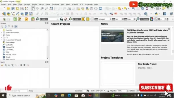
To generate the Python code:
- Open the DeepSeek AI application.
- Enter your mapping request in the chat interface (e.g., 'Please provide GeoJSON Python code to visualize the coordinates of major U.S. airports in the QGIS Python console.').
- Use the DeepThink feature for the AI to analyze your request more thoroughly.
- Send the prompt.
DeepSeek AI will process your query and output a customized Python code snippet in GeoJSON format. This code contains the necessary geospatial data and instructions to create your map in QGIS.
Here's an example of Python code that it could generate:
{"type": "FeatureCollection","features": [{"type": "Feature","properties": {"name": "Statue of Liberty","description": "Iconic symbol of freedom in New York Harbor"},"geometry": {"type": "Point","coordinates": [-74.0445, 40.6892]}},{"type": "Feature","properties": {"name": "Golden Gate Bridge","description": "Famous suspension bridge in San Francisco"},"geometry": {"type": "Point","coordinates": [-122.4783, 37.8199]}}]}
Executing the Python Code in QGIS
Once you have the GeoJSON Python code from DeepSeek AI, copy it and follow these steps to run it in QGIS:
In QGIS, navigate to 'Plugins' -> 'Python Console'.
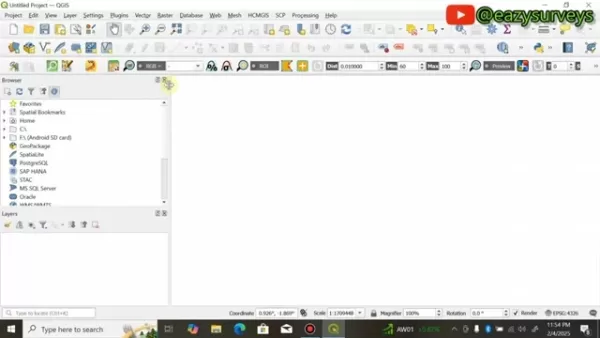
Click the 'Show Editor' button.
Paste the AI-generated Python code into the editor window.
Click the 'Run Script' button.
Executing the script will generate a GeoJSON file in a designated directory, ready to be used for mapping within QGIS.
Importing the GeoJSON File into QGIS and Adding Basemap
After running the script, import the resulting GeoJSON file into QGIS and add a base map to provide geographical context.
In QGIS, select 'Layer' -> 'Add Layer' -> 'Add Vector Layer...'.
Click the browse button.
Navigate to and select the saved GeoJSON file.
Click 'Add' and then 'Close'.
Review the coordinate reference system information presented.
To add a base map programmatically, you can include additional Python code beneath the GeoJSON data in your script.
Enhance your map's context by adding a tile layer like OpenStreetMap or Google Maps. You can install these via the QuickMapServices plugin. This overlays your data on a real-world map, providing essential reference points.
Enhancing Map Visualization with Symbolization
Effective symbolization is crucial for creating readable and visually compelling maps. QGIS provides extensive options to customize how map features appear.
You can adjust the color, size, shape, and transparency of points, lines, and polygons to craft an informative and engaging visual story.
To modify a layer's symbology:
- In the 'Layers' panel, right-click on the target layer.
- Choose 'Properties'.
- Navigate to the 'Symbology' tab.
- Experiment with the various styling options to achieve your desired visual effect.
Thoughtful symbology helps emphasize key features, clarify spatial relationships, and ensure your map communicates its message effectively.
Case Study: Mapping Important U.S. Landmarks with DeepSeek AI and QGIS
Identifying Key Landmarks Using DeepSeek AI
To illustrate the practical application of DeepSeek AI in QGIS, consider a case study focused on mapping significant U.S. landmarks. For this example, DeepSeek AI is prompted with: "Please provide GeoJSON Python code to visualize the coordinates of important places in the United States within QGIS."
In response, DeepSeek AI generates a tailored GeoJSON Python code snippet containing coordinates for several notable landmarks.
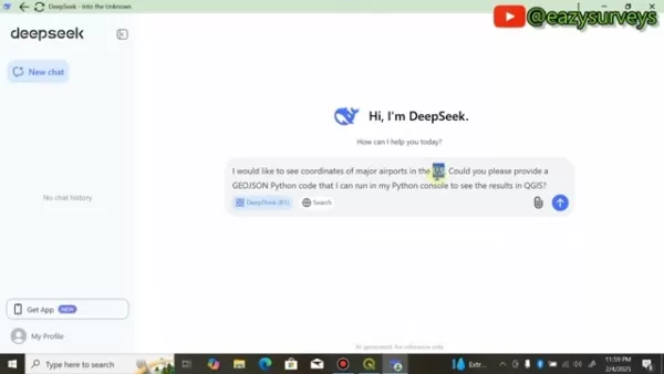
This code is immediately ready for execution in QGIS. While this prompt focused on statues, modifying the request to DeepSeek AI can yield GeoJSON data for virtually any feature or location.
Visualizing Landmarks on the QGIS Map
Running the script in the QGIS Python Console plots several significant sites, such as the Statue of Liberty, the Golden Gate Bridge, the Grand Canyon, Mount Rushmore, and the White House.
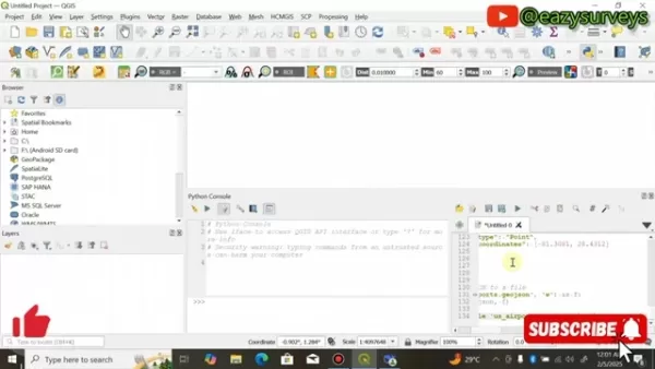
The process also includes adding a base map for geographical context. In each instance, the AI guides the user, minimizing or eliminating the need for manual coding expertise.
DeepSeek AI and QGIS: Weighing the Advantages and Disadvantages
Pros
Intuitive and User-Friendly
Requires No Prior Coding Knowledge
Significantly Reduces Project Time
Highly Accessible to All Users
Creates a Streamlined, Efficient Workflow
Cons
Output Quality Depends on AI Accuracy
May Be Less Suited for Highly Complex or Specialized Datasets
Frequently Asked Questions
Is QGIS really free?
Absolutely. QGIS is released under the GNU General Public License (GPL). This means it is completely free to use, share, and modify, with no licensing costs whatsoever.
Do I need coding experience to use DeepSeek AI for mapping in QGIS?
No coding experience is necessary. DeepSeek AI generates all required Python code, making advanced mapping accessible to beginners and experts alike. This is a core advantage of the tool.
What type of geospatial data can DeepSeek AI handle?
DeepSeek AI primarily outputs data in the widely supported GeoJSON format. This covers standard vector data types like points (locations), lines (roads, rivers), and polygons (areas, boundaries).
Can I use DeepSeek AI to create maps for any location in the world?
Yes, DeepSeek AI can generate maps for any global location, provided you supply accurate and specific location details in your request.
Do I need to pay for DeepSeek Ai
No, it is a free and open-source tool. More details are available on the official DeepSeek website.
Related Questions
Can DeepSeek AI be used for advanced geospatial analysis?
DeepSeek AI's capabilities extend well beyond basic mapping. It can be applied to sophisticated geospatial analyses, such as proximity studies, overlay operations, and network analysis. For instance, a real estate analyst could use it to find development sites based on zoning, transport links, and environmental factors. An environmental scientist could employ it to track deforestation, map biodiversity, or model climate change impacts. An urban planner could leverage it to optimize transit networks, plan infrastructure, or develop sustainable city strategies. The potential applications are extensive and continually growing.
Related article
 South Korea Breaks Ground on National AI Computing Center, Investing 2.5 Trillion Won with 2028 Target
South Korean outlet EtNews reports that groundbreaking for the Korea AI Computing Center (KOACC) took place on August 3 at the Solar City data center park in Sunan, Jeollanam-do. Backed by a total investment of 2.5 trillion KRW (roughly 11.838 billio
Six Tech Giants Back Linux Foundation With $12.5M to Tackle AI Vulnerability Noise
To tackle the flood of low-quality security reports produced by AI automation tools, six major tech companies—Anthropic, Amazon (AWS), GitHub, Google, Microsoft, and OpenAI—have collectively contributed $12.5 million in funding to Linux Foundation in
Musk Considered Leaving OpenAI to His Kids as Altman Testifies
This morning, OpenAI CEO Sam Altman took the stand to address former co-founder Elon Musk’s lawsuit challenging the company’s corporate structure.When asked about Musk’s claim that other founders “stole a charity” by launching a for-profit subsidiary
Related Special Topic Recommendations
Music composition
South Korea Breaks Ground on National AI Computing Center, Investing 2.5 Trillion Won with 2028 Target
South Korean outlet EtNews reports that groundbreaking for the Korea AI Computing Center (KOACC) took place on August 3 at the Solar City data center park in Sunan, Jeollanam-do. Backed by a total investment of 2.5 trillion KRW (roughly 11.838 billio
Six Tech Giants Back Linux Foundation With $12.5M to Tackle AI Vulnerability Noise
To tackle the flood of low-quality security reports produced by AI automation tools, six major tech companies—Anthropic, Amazon (AWS), GitHub, Google, Microsoft, and OpenAI—have collectively contributed $12.5 million in funding to Linux Foundation in
Musk Considered Leaving OpenAI to His Kids as Altman Testifies
This morning, OpenAI CEO Sam Altman took the stand to address former co-founder Elon Musk’s lawsuit challenging the company’s corporate structure.When asked about Musk’s claim that other founders “stole a charity” by launching a for-profit subsidiary
Related Special Topic Recommendations
Music composition
 AI Vocal Demo Tools for Songwriters, Hooks, Toplines, and Multilingual Draft Sessions
2026 Latest Best AI Vocal Demo Tools for Songwriters, Hook Creators, and Multi-Language Content Teams! XIX.AI has curated a top-rated list of powerful game-changing tools that go through rigorous real-world tests. You’ll find detailed free vs paid comparison data, comprehensive rankings, and must-try options to help you boost writing efficiency and unlock your creative potential. Explore now to discover your perfect tool for all your content needs!
 9 tools
 xix.ai
Business
Best AI Competitive Research Tools for Small Businesses
xix.ai
Business
Best AI Competitive Research Tools for Small Businesses
2026 Latest Best Top-rated AI Competitive Research Tools for Small Businesses! XIX.AI has curated a highly powerful game-changing collection, updated weekly with rigorous real-world tests and detailed rankings. You can find a comprehensive free vs paid comparison to help you identify the must-try tools that boost your productivity and give you a competitive edge. Explore now to discover your perfect tool!
9 tools
xix.ai
Image editing
Photoshop AI Retouch Tools for Ecommerce Apparel, Skin Cleanup, and Color Consistency
2026 Latest Best Photoshop AI retouch tools for ecommerce apparel, skin cleanup, and color consistency! This top-rated curated list features powerful game-changing solutions that help you boost writing efficiency, streamline content creation, and achieve perfect visual results effortlessly. Each tool has undergone real-world tests through weekly updated rankings, complete with free vs paid comparison details. Backed by XIX.AI, it’s the must-try guide for anyone aiming to unlock your AI edge. Explore now!
10 tools
xix.ai
Prompt
Best AI Prompt Libraries for ChatGPT Workflows
2026 Latest Best Top-Rated AI Prompt Libraries for optimizing all types of ChatGPT workflows. XIX.AI has curated a powerful, game-changing collection that goes through rigorous real-world tests to ensure top performance. You can find detailed free vs paid comparisons and expert rankings to help you choose the must-try tools that boost your productivity and unlock your AI edge. Explore now!
11 tools
xix.ai
Education and Learning
AI Quiz Builder Platforms for Teachers, Tutors, and Cohort-Based Learning Programs
2026 Latest Best AI Quiz Builder Platforms for Teachers, Tutors, and Cohort-Based Learning Programs! XIX.AI has curated a top-rated list of powerful game-changing tools that go through real-world tests to deliver accurate rankings. These must-try platforms help boost writing efficiency, streamline content creation, and simplify quiz design across all learning scenarios. Explore now to discover your perfect tool for unlocking your AI edge in teaching!
13 tools
xix.ai
code
AI Pull Request Review Tools for GitHub Teams Handling Refactors, Bugs, and Security Gaps
2026 Latest Best AI Pull Request Review Tools for GitHub Teams are here on XIX.AI! This top-rated curated list showcases powerful game-changing solutions that streamline refactoring, bug fixing, and security gap detection across all team workflows. Enjoy a free vs paid comparison along with real-world tests and detailed rankings to help you find the perfect tool that boosts productivity significantly. Explore now to unlock your AI edge!
12 tools
xix.ai

 Comments (2)
0/500
Comments (2)
0/500
![GaryGonzalez]()
この記事、GISとAIの組み合わせは本当に面白いですね。特にオープンソースのQGISでDeepSeekが使えるって、コスト面でもすごく助かる。2025年までにこんなに進化してるのか…自分も試してみたくなりました!🗺️
![HarryPerez]()
Геоинформационные системы всегда казались такими сложными, но с ИИ всё меняется! Интересно, насколько DeepSeek действительно упрощает картографирование? Может быть, стоит попробовать на своих проектах. 🤔 Кстати, а как ИИ справляется с неточными данными - вот это было бы интересно узнать подробнее!
Artificial Intelligence is transforming geospatial workflows, bringing new levels of efficiency and insight. This article explores the practical integration of DeepSeek AI with QGIS, the powerful open-source Geographic Information System. Learn how this combination streamlines surveying and mapping, making advanced techniques more accessible for professionals and hobbyists. By leveraging DeepSeek AI's intelligent automation alongside QGIS's robust toolkit, users can achieve remarkable precision and productivity in their spatial projects.
Key Points
DeepSeek AI delivers AI-assisted mapping capabilities directly within QGIS.
QGIS is a comprehensive, free, and open-source Geographic Information System.
Integrating DeepSeek AI simplifies and accelerates complex mapping workflows.
The JSON Eater plugin is essential for processing data from DeepSeek AI.
Users can generate custom GeoJSON Python code tailored to their queries using DeepSeek AI.
Base maps can be added automatically through executed Python scripts.
Effective symbolization in QGIS significantly improves map clarity and visual impact.
Integrating DeepSeek AI for Mapping in QGIS
What is QGIS and Why Use It?
QGIS is a premier open-source Geographic Information System renowned for its power and flexibility.
Its accessibility and extensive capabilities have made it the go-to choice for surveyors, cartographers, and researchers worldwide. Being free eliminates cost barriers and fosters widespread use. Its modular plugin architecture lets users customize the platform for specialized tasks, enhancing its versatility. A vibrant, active community provides ample support and learning resources for all experience levels. Regular updates ensure QGIS stays at the cutting edge of geospatial innovation.
QGIS offers a comprehensive suite of tools for mapping and spatial analysis, including:
- Robust handling of vector and raster data formats
- A vast library of geoprocessing algorithms
- Advanced cartographic design and layout tools
- Extensible functionality through a rich ecosystem of plugins
These strengths, combined with its open-source philosophy, make QGIS the perfect foundation for integrating AI-powered solutions like DeepSeek AI.
Unveiling DeepSeek AI: AI-Powered Mapping Assistant
DeepSeek AI is a cutting-edge application designed to automate and enhance mapping processes. It uses artificial intelligence to handle tasks like data extraction, feature identification, and map generation. Integrating it with QGIS unlocks superior efficiency and accuracy for geospatial projects. It can produce custom GeoJSON Python code based on user prompts, allowing for targeted data extraction and visualization within QGIS. A key benefit is its user-friendly design, which lowers the technical barrier to entry.
At its core, DeepSeek AI functions as an intelligent partner, interpreting user requests and delivering bespoke solutions. For instance, a user can ask it to map all major U.S. airports, and the AI will produce the precise Python code to extract and display that data in QGIS.
How to install the JSON Eater Plugin: Essential for DeepSeek AI Integration
A critical prerequisite for using DeepSeek AI is installing the JSON Eater plugin. This plugin allows QGIS to interpret and process the GeoJSON Python code generated by the AI.
Follow these steps to install the JSON Eater plugin:
- Open QGIS.
- Go to the 'Plugins' menu.
- Select 'Manage and Install Plugins...'.
- In the 'All' tab, search for 'JSON Eater'.
- Click the 'Install Plugin' button.
Note: A stable internet connection is required during installation.
The JSON Eater plugin acts as a vital bridge, translating the AI-generated code into a format QGIS can understand and display. It is free to use, and its absence would severely limit the integration between DeepSeek AI and QGIS.
Generating GeoJSON Python Code using DeepSeek AI
With the JSON Eater plugin installed, you can start using DeepSeek AI to generate GeoJSON Python code for your specific mapping needs.
To generate the Python code:
- Open the DeepSeek AI application.
- Enter your mapping request in the chat interface (e.g., 'Please provide GeoJSON Python code to visualize the coordinates of major U.S. airports in the QGIS Python console.').
- Use the DeepThink feature for the AI to analyze your request more thoroughly.
- Send the prompt.
DeepSeek AI will process your query and output a customized Python code snippet in GeoJSON format. This code contains the necessary geospatial data and instructions to create your map in QGIS.
Here's an example of Python code that it could generate:
{"type": "FeatureCollection","features": [{"type": "Feature","properties": {"name": "Statue of Liberty","description": "Iconic symbol of freedom in New York Harbor"},"geometry": {"type": "Point","coordinates": [-74.0445, 40.6892]}},{"type": "Feature","properties": {"name": "Golden Gate Bridge","description": "Famous suspension bridge in San Francisco"},"geometry": {"type": "Point","coordinates": [-122.4783, 37.8199]}}]}
Executing the Python Code in QGIS
Once you have the GeoJSON Python code from DeepSeek AI, copy it and follow these steps to run it in QGIS:
In QGIS, navigate to 'Plugins' -> 'Python Console'.
Click the 'Show Editor' button.
Paste the AI-generated Python code into the editor window.
Click the 'Run Script' button.
Executing the script will generate a GeoJSON file in a designated directory, ready to be used for mapping within QGIS.
Importing the GeoJSON File into QGIS and Adding Basemap
After running the script, import the resulting GeoJSON file into QGIS and add a base map to provide geographical context.
In QGIS, select 'Layer' -> 'Add Layer' -> 'Add Vector Layer...'.
Click the browse button.
Navigate to and select the saved GeoJSON file.
Click 'Add' and then 'Close'.
Review the coordinate reference system information presented.
To add a base map programmatically, you can include additional Python code beneath the GeoJSON data in your script.
Enhance your map's context by adding a tile layer like OpenStreetMap or Google Maps. You can install these via the QuickMapServices plugin. This overlays your data on a real-world map, providing essential reference points.
Enhancing Map Visualization with Symbolization
Effective symbolization is crucial for creating readable and visually compelling maps. QGIS provides extensive options to customize how map features appear.
You can adjust the color, size, shape, and transparency of points, lines, and polygons to craft an informative and engaging visual story.
To modify a layer's symbology:
- In the 'Layers' panel, right-click on the target layer.
- Choose 'Properties'.
- Navigate to the 'Symbology' tab.
- Experiment with the various styling options to achieve your desired visual effect.
Thoughtful symbology helps emphasize key features, clarify spatial relationships, and ensure your map communicates its message effectively.
Case Study: Mapping Important U.S. Landmarks with DeepSeek AI and QGIS
Identifying Key Landmarks Using DeepSeek AI
To illustrate the practical application of DeepSeek AI in QGIS, consider a case study focused on mapping significant U.S. landmarks. For this example, DeepSeek AI is prompted with: "Please provide GeoJSON Python code to visualize the coordinates of important places in the United States within QGIS."
In response, DeepSeek AI generates a tailored GeoJSON Python code snippet containing coordinates for several notable landmarks.
This code is immediately ready for execution in QGIS. While this prompt focused on statues, modifying the request to DeepSeek AI can yield GeoJSON data for virtually any feature or location.
Visualizing Landmarks on the QGIS Map
Running the script in the QGIS Python Console plots several significant sites, such as the Statue of Liberty, the Golden Gate Bridge, the Grand Canyon, Mount Rushmore, and the White House.
The process also includes adding a base map for geographical context. In each instance, the AI guides the user, minimizing or eliminating the need for manual coding expertise.
DeepSeek AI and QGIS: Weighing the Advantages and Disadvantages
Pros
Intuitive and User-Friendly
Requires No Prior Coding Knowledge
Significantly Reduces Project Time
Highly Accessible to All Users
Creates a Streamlined, Efficient Workflow
Cons
Output Quality Depends on AI Accuracy
May Be Less Suited for Highly Complex or Specialized Datasets
Frequently Asked Questions
Is QGIS really free?
Absolutely. QGIS is released under the GNU General Public License (GPL). This means it is completely free to use, share, and modify, with no licensing costs whatsoever.
Do I need coding experience to use DeepSeek AI for mapping in QGIS?
No coding experience is necessary. DeepSeek AI generates all required Python code, making advanced mapping accessible to beginners and experts alike. This is a core advantage of the tool.
What type of geospatial data can DeepSeek AI handle?
DeepSeek AI primarily outputs data in the widely supported GeoJSON format. This covers standard vector data types like points (locations), lines (roads, rivers), and polygons (areas, boundaries).
Can I use DeepSeek AI to create maps for any location in the world?
Yes, DeepSeek AI can generate maps for any global location, provided you supply accurate and specific location details in your request.
Do I need to pay for DeepSeek Ai
No, it is a free and open-source tool. More details are available on the official DeepSeek website.
Related Questions
Can DeepSeek AI be used for advanced geospatial analysis?
DeepSeek AI's capabilities extend well beyond basic mapping. It can be applied to sophisticated geospatial analyses, such as proximity studies, overlay operations, and network analysis. For instance, a real estate analyst could use it to find development sites based on zoning, transport links, and environmental factors. An environmental scientist could employ it to track deforestation, map biodiversity, or model climate change impacts. An urban planner could leverage it to optimize transit networks, plan infrastructure, or develop sustainable city strategies. The potential applications are extensive and continually growing.








 South Korea Breaks Ground on National AI Computing Center, Investing 2.5 Trillion Won with 2028 Target
South Korean outlet EtNews reports that groundbreaking for the Korea AI Computing Center (KOACC) took place on August 3 at the Solar City data center park in Sunan, Jeollanam-do. Backed by a total investment of 2.5 trillion KRW (roughly 11.838 billio
South Korea Breaks Ground on National AI Computing Center, Investing 2.5 Trillion Won with 2028 Target
South Korean outlet EtNews reports that groundbreaking for the Korea AI Computing Center (KOACC) took place on August 3 at the Solar City data center park in Sunan, Jeollanam-do. Backed by a total investment of 2.5 trillion KRW (roughly 11.838 billio
 Six Tech Giants Back Linux Foundation With $12.5M to Tackle AI Vulnerability Noise
To tackle the flood of low-quality security reports produced by AI automation tools, six major tech companies—Anthropic, Amazon (AWS), GitHub, Google, Microsoft, and OpenAI—have collectively contributed $12.5 million in funding to Linux Foundation in
Six Tech Giants Back Linux Foundation With $12.5M to Tackle AI Vulnerability Noise
To tackle the flood of low-quality security reports produced by AI automation tools, six major tech companies—Anthropic, Amazon (AWS), GitHub, Google, Microsoft, and OpenAI—have collectively contributed $12.5 million in funding to Linux Foundation in
 Musk Considered Leaving OpenAI to His Kids as Altman Testifies
This morning, OpenAI CEO Sam Altman took the stand to address former co-founder Elon Musk’s lawsuit challenging the company’s corporate structure.When asked about Musk’s claim that other founders “stole a charity” by launching a for-profit subsidiary
Musk Considered Leaving OpenAI to His Kids as Altman Testifies
This morning, OpenAI CEO Sam Altman took the stand to address former co-founder Elon Musk’s lawsuit challenging the company’s corporate structure.When asked about Musk’s claim that other founders “stole a charity” by launching a for-profit subsidiary

2026 Latest Best AI Vocal Demo Tools for Songwriters, Hook Creators, and Multi-Language Content Teams! XIX.AI has curated a top-rated list of powerful game-changing tools that go through rigorous real-world tests. You’ll find detailed free vs paid comparison data, comprehensive rankings, and must-try options to help you boost writing efficiency and unlock your creative potential. Explore now to discover your perfect tool for all your content needs!
9 tools
xix.ai

2026 Latest Best Top-rated AI Competitive Research Tools for Small Businesses! XIX.AI has curated a highly powerful game-changing collection, updated weekly with rigorous real-world tests and detailed rankings. You can find a comprehensive free vs paid comparison to help you identify the must-try tools that boost your productivity and give you a competitive edge. Explore now to discover your perfect tool!
9 tools
xix.ai

2026 Latest Best Photoshop AI retouch tools for ecommerce apparel, skin cleanup, and color consistency! This top-rated curated list features powerful game-changing solutions that help you boost writing efficiency, streamline content creation, and achieve perfect visual results effortlessly. Each tool has undergone real-world tests through weekly updated rankings, complete with free vs paid comparison details. Backed by XIX.AI, it’s the must-try guide for anyone aiming to unlock your AI edge. Explore now!
10 tools
xix.ai

2026 Latest Best Top-Rated AI Prompt Libraries for optimizing all types of ChatGPT workflows. XIX.AI has curated a powerful, game-changing collection that goes through rigorous real-world tests to ensure top performance. You can find detailed free vs paid comparisons and expert rankings to help you choose the must-try tools that boost your productivity and unlock your AI edge. Explore now!
11 tools
xix.ai

2026 Latest Best AI Quiz Builder Platforms for Teachers, Tutors, and Cohort-Based Learning Programs! XIX.AI has curated a top-rated list of powerful game-changing tools that go through real-world tests to deliver accurate rankings. These must-try platforms help boost writing efficiency, streamline content creation, and simplify quiz design across all learning scenarios. Explore now to discover your perfect tool for unlocking your AI edge in teaching!
13 tools
xix.ai

2026 Latest Best AI Pull Request Review Tools for GitHub Teams are here on XIX.AI! This top-rated curated list showcases powerful game-changing solutions that streamline refactoring, bug fixing, and security gap detection across all team workflows. Enjoy a free vs paid comparison along with real-world tests and detailed rankings to help you find the perfect tool that boosts productivity significantly. Explore now to unlock your AI edge!
12 tools
xix.ai

この記事、GISとAIの組み合わせは本当に面白いですね。特にオープンソースのQGISでDeepSeekが使えるって、コスト面でもすごく助かる。2025年までにこんなに進化してるのか…自分も試してみたくなりました!🗺️
Геоинформационные системы всегда казались такими сложными, но с ИИ всё меняется! Интересно, насколько DeepSeek действительно упрощает картографирование? Может быть, стоит попробовать на своих проектах. 🤔 Кстати, а как ИИ справляется с неточными данными - вот это было бы интересно узнать подробнее!