

 Home
HomeMicrosoft, Azure and AI Tech Combat California Wildfire Risks
![Firefighting helicopter battling the Sandy Fire in Simi Valley, California on May 18, 2026. Image: Getty]()
Microsoft invests in AI-driven wildfire detection, with Juan Lavista Ferres, CVP and Chief Data Scientist, discussing strategies to mitigate environmental damage.
According to NASA, climate change impacts everyone on Earth, manifesting as rising temperatures, altered rainfall patterns, and sea-level rise.
NASA states there is unequivocal evidence that Earth is warming at an unprecedented rate, with human activity as the primary driver.
As global temperatures rise, wildfires pose an escalating threat.
In the US, rising temperatures, prolonged droughts, and expanding development heighten risks to communities and ecosystems.
Last year, nearly 78,000 wildfires were reported nationwide, marking a 20% increase from the previous year.
In California, where fire has historically shaped forests, grasslands, and coastal landscapes, the challenge increasingly involves managing how communities coexist with climate change impacts.
Scientists, firefighters, and Microsoft's AI for Good Lab are leveraging AI to detect wildfires earlier, providing emergency teams with more response time.
We aim to make this technology accessible globally.
Juan Lavista Ferres, Vice President and Chief Data Scientist at Microsoft’s AI for Good Lab.
Microsoft has committed $5 million to advance AI-powered wildfire detection, funding the expansion of real-time computer vision systems that demonstrate new approaches to deploying machine learning in time-critical environmental monitoring.
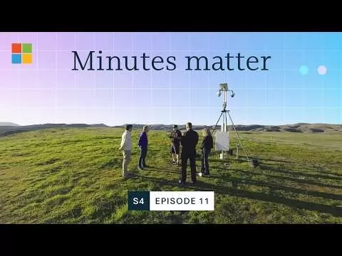
How technology helps prevent wildfire spread
Computer vision at scale
For decades, wildfire detection relied on people spotting smoke from roads, lookout points, or nearby communities before alerting emergency services.
ALERTCalifornia, founded at the University of California San Diego, is transforming this approach with a network of nearly 1,300 cameras across fire-prone areas of the state.
The system continuously monitors live camera feeds and uses AI to identify potential smoke signs.
It compares different camera angles, verifies fire locations, and sends alerts to emergency teams within minutes.
In its first two months, the network detected 77 incidents before they were reported through other channels.
The system now processes over seven million images daily, identifying wildfires up to 2.5 hours before the first 911 call.
The AI model must distinguish genuine fire signatures from environmental noise, such as clouds, fog, and variable lighting conditions across different times of day and seasons.
This classification challenge is compounded by the diversity of monitored landscapes, from dense forests to grasslands and coastal regions.
Dr. Neal Driscoll, Geophysicist and Founder of ALERTCalifornia, states: “The data reveals not just what the landscape looks like.
Dr. Neal Driscoll, Geophysicist and Founder, ALERTCalifornia. Credit: Emily Zheng via Microsoft
“It helps us understand how it changes over time.”
According to the project's operational data, detecting fires 2.5 hours before traditional methods indicates the model's sensitivity threshold has been calibrated to identify smoke at early stages while maintaining acceptable precision.
Model performance in production
The system's deployment highlights practical considerations for AI systems operating in critical detection scenarios.
Processing seven million images daily requires infrastructure capable of handling continuous inference at scale, with the Azure grant component of Microsoft's $5 million contribution potentially addressing computational needs.
Wildfire facts from Earth.Org
- Wildfires require three key conditions to ignite: dry vegetation (fuel), oxygen-rich air, and a heat source. Strong winds can accelerate spread.
- Lightning triggers wildfires naturally: Lightning is a major natural ignition source, with hotter, longer strikes more likely to start fires. A 2014 study found a 1°C temperature rise could increase lightning frequency by 12%.
- Over 80% of US wildfires are human-caused: Activities like unattended campfires, cigarettes, barbecues, and pyrotechnics account for about 84% of wildfires in the US.
- Wildfires cause widespread air pollution: Smoke contains gases and fine particles that travel long distances, penetrating deep into lungs and increasing respiratory and cardiovascular health risks.
- Climate change lengthens wildfire seasons: Rising temperatures, drought, and reduced rainfall leave more vegetation dry and flammable. In the US, fire seasons once lasting four months now extend for six to eight months or more.
- Wildfires create a climate feedback loop: Large-scale fires release substantial greenhouse gases while destroying carbon-storing vegetation, contributing to further warming and increasing the likelihood and intensity of future wildfires.
In 2023, the system's detection capabilities helped contain Kern County, US's Trotter Fire at 52 acres, with projections suggesting it could have reached nearly 4,000 acres without AI intervention.
These real-world outcomes offer case studies for evaluating model impact beyond standard accuracy metrics.
The technology's role during Sonoma County, US's Kincade Fire in 2019, supporting the evacuation of over 180,000 residents without loss of life, demonstrates how early warning systems influence emergency response protocols.
"We gain significant knowledge in the first five minutes," says Zachary Wells, Deputy Chief of the Kern County Fire Department and Deputy Director of Operations for ALERTCalifornia.
Zachary Wells, Deputy Chief, Kern County Fire Department and Deputy Director of Operations, ALERTCalifornia. Credit: Emily Zheng
"That early understanding informs all subsequent actions."
Deployment scalability and adaptation
Microsoft's funding structure, comprising $2 million for technology development and a $3 million Azure grant, indicates priorities around both model enhancement and computational infrastructure.
"We want this technology to be available to people across the world," says Juan Lavista Ferres, Vice President and Chief Data Scientist at Microsoft’s AI for Good Lab.
Juan Lavista Ferres, CVP & Chief Data Scientist at Microsoft
Scaling the approach beyond California presents technical challenges regarding model generalization and transfer learning.
Wildfire risks vary significantly by location, meaning systems must account for local landscapes, vegetation, weather conditions, and emergency response structures.
A model trained primarily on California data may require fine-tuning or retraining when deployed in regions with different vegetation types, topography, or climate patterns.
The project is also developing capabilities beyond initial detection, incorporating nearly 98,000 square miles of LiDAR data to create detailed digital landscape models.
This expansion into terrain mapping, forest health monitoring, and post-fire risk assessment suggests a broader data pipeline architecture.
Combining computer vision for smoke detection with LiDAR-derived environmental data enables multi-task learning approaches that improve overall system intelligence and provide additional use cases for the underlying infrastructure and datasets.

AI-powered imaging accelerates wildfire detection
Fast Facts on Climate from the United Nations
- Global surface temperature has increased faster since 1970 than in any other 50-year period over at least the last 2,000 years.
- The Earth is now approximately 1.42°C warmer than in the pre-industrial era (1850-1900).
- 2024 was the warmest year on record, with the global average near-surface temperature 1.55°C above the pre-industrial baseline.
- 2015-2024 was the warmest recorded decade.
- Every fraction of a degree of warming matters. With each additional increment of global warming, changes in extremes and risks increase.
- Carbon dioxide (CO2) is accumulating in the atmosphere faster than at any time during human existence, rising by more than 10% in just two decades.
Microsoft AI for Good Lab Projects
Aurora forecasting:Microsoft’s Aurora Forecasting project uses a 1.3 billion-parameter AI foundation model to analyze atmospheric data and improve weather and climate forecasting. The model supports applications including weather prediction, air quality modeling, and extreme weather analysis, demonstrating how AI can process complex environmental datasets to strengthen understanding of atmospheric conditions and support resilience planning.
Geospatial machine learning: Microsoft’s AI for Good Lab combines geospatial data, satellite and aerial imagery with machine learning in collaboration with universities, conservation agencies, NGOs, and Turkey’s Ministry of Interior Disaster and Emergency Management Presidency. Projects include earthquake building damage assessment, glacier and land-cover mapping, poultry barn mapping, and renewable energy monitoring, supporting disaster response, conservation, humanitarian action, and environmental planning.
Glacier mapping: Microsoft’s AI for Good Lab uses machine learning and satellite imagery to support glacier mapping and ecological monitoring in the Hindu Kush Himalaya region. The project identifies and outlines both clean ice and debris-covered glaciers, while a web tool allows experts to review and correct model predictions. The approach aims to accelerate mapping and improve understanding of glacier ecosystems affected by climate change.
Renewable energy mapping: Microsoft’s Renewable Energy Mapping project uses geospatial machine learning to map and monitor renewable energy development at scale. The technology helps organizations understand where renewable infrastructure is being developed and track changes across large areas. By combining AI with geospatial information, the project demonstrates how machine learning can support renewable energy planning and provide data for monitoring the transition to cleaner energy.
Bioacoustics: Microsoft’s AI for Good Lab collaborates with conservation organizations and research labs to apply machine learning and deep learning to large volumes of wildlife audio. Projects include Project Guacamaya, in partnership with the Humboldt Institute, using bioacoustics for species identification in the Amazon. Other work supports beluga whale monitoring and automated classification of bird and amphibian calls, advancing biodiversity research and conservation.
Accelerating biodiversity surveys: Microsoft’s AI for Good Lab, Microsoft Research, and Microsoft AI for Earth collaborate with NOAA Fisheries, Sieve Analytics, and LILA BC to accelerate biodiversity surveys using machine learning. The projects analyze imagery and audio from camera traps, aerial cameras, and microphones, reducing manual annotation. This work aims to provide conservationists with wildlife population data faster, supporting decisions on habitat protection, infrastructure, and anti-poaching efforts.
Land cover mapping: Microsoft’s Land Cover Mapping work uses computer vision to turn remote sensing data into land-use and land-cover information. The approach reduces the time environmental scientists and geospatial analysts spend manually mapping areas, allowing more focus on analysis and decision-making. By automating parts of the mapping process, Microsoft supports environmental monitoring and helps organizations work with large-scale geospatial datasets.
Related article
 Google Tests Remy AI Agent for Gemini as Focus Shifts to User Control
According to Business Insider, Google is testing Remy, a new AI personal agent for Gemini. This tool aims to execute tasks on behalf of users, streamlining both professional workflows and daily routines.Currently, Remy is undergoing testing in an int
Ollie bets privacy focus to win AI assistant race
To be genuinely helpful, an AI assistant must understand its user deeply. Ollie, a personal assistant designed for daily life, operates on the premise that this doesn’t require surrendering your data or compromising your privacy.While certain enterpr
How AI LIVE: London Will Explore AI & Industrial Automation
The summit will convene C-suite executives from around the globe to address pressing challenges in global industries, ranging from AI-driven disruption to economic volatility.AI LIVE: The London Summit will gather over 2,000 international leaders und
Related Special Topic Recommendations
Data Analysis
Google Tests Remy AI Agent for Gemini as Focus Shifts to User Control
According to Business Insider, Google is testing Remy, a new AI personal agent for Gemini. This tool aims to execute tasks on behalf of users, streamlining both professional workflows and daily routines.Currently, Remy is undergoing testing in an int
Ollie bets privacy focus to win AI assistant race
To be genuinely helpful, an AI assistant must understand its user deeply. Ollie, a personal assistant designed for daily life, operates on the premise that this doesn’t require surrendering your data or compromising your privacy.While certain enterpr
How AI LIVE: London Will Explore AI & Industrial Automation
The summit will convene C-suite executives from around the globe to address pressing challenges in global industries, ranging from AI-driven disruption to economic volatility.AI LIVE: The London Summit will gather over 2,000 international leaders und
Related Special Topic Recommendations
Data Analysis
 Best AI Anomaly Detection Tools for KPI Monitoring across SaaS and Ecommerce Teams
2026 Latest Best Top-rated AI Anomaly Detection Tools for KPI Monitoring in SaaS and Ecommerce teams! XIX.AI has curated a powerful, game-changing collection based on rigorous real-world tests and weekly updated rankings. You’ll find detailed free vs paid comparison insights to help you identify the must-try solution that boosts productivity and unlocks your AI edge. Explore now!
 10 tools
 xix.ai
writing
Best AI Outline Generators for Long-Form SEO Articles
xix.ai
writing
Best AI Outline Generators for Long-Form SEO Articles
2026 Latest Best Top-Rated AI Outline Generators for Long-Form SEO Articles, meticulously curated by XIX.AI. These powerful tools offer game-changing assistance in creating high-quality content quickly, boosting writing efficiency significantly. Get a free vs paid comparison along with real-world tests and detailed rankings to help you find the must-try option that suits your needs. Explore now to unlock your AI edge.
8 tools
xix.ai
Education and Learning
AI Study Tools for Homework and Exam Prep
2026 Latest Best AI Study Tools for Homework and Exam Prep! XIX.AI curates a top-rated list of powerful, game-changing tools that help students boost productivity, streamline homework completion, and ace exams through real-world tests. Get a free vs paid comparison, detailed rankings, and must-try options to unlock your AI edge. Explore now!
10 tools
xix.ai
Music composition
AI Vocal Demo Tools for Songwriters, Hooks, Toplines, and Multilingual Draft Sessions
2026 Latest Best AI Vocal Demo Tools for Songwriters, Hook Creators, and Multi-Language Content Teams! XIX.AI has curated a top-rated list of powerful game-changing tools that go through rigorous real-world tests. You’ll find detailed free vs paid comparison data, comprehensive rankings, and must-try options to help you boost writing efficiency and unlock your creative potential. Explore now to discover your perfect tool for all your content needs!
9 tools
xix.ai
Business
Best AI Competitive Research Tools for Small Businesses
2026 Latest Best Top-rated AI Competitive Research Tools for Small Businesses! XIX.AI has curated a highly powerful game-changing collection, updated weekly with rigorous real-world tests and detailed rankings. You can find a comprehensive free vs paid comparison to help you identify the must-try tools that boost your productivity and give you a competitive edge. Explore now to discover your perfect tool!
9 tools
xix.ai
Image editing
Photoshop AI Retouch Tools for Ecommerce Apparel, Skin Cleanup, and Color Consistency
2026 Latest Best Photoshop AI retouch tools for ecommerce apparel, skin cleanup, and color consistency! This top-rated curated list features powerful game-changing solutions that help you boost writing efficiency, streamline content creation, and achieve perfect visual results effortlessly. Each tool has undergone real-world tests through weekly updated rankings, complete with free vs paid comparison details. Backed by XIX.AI, it’s the must-try guide for anyone aiming to unlock your AI edge. Explore now!
10 tools
xix.ai

 Comments (0)
0/500
Comments (0)
0/500
Microsoft invests in AI-driven wildfire detection, with Juan Lavista Ferres, CVP and Chief Data Scientist, discussing strategies to mitigate environmental damage.
According to NASA, climate change impacts everyone on Earth, manifesting as rising temperatures, altered rainfall patterns, and sea-level rise.
NASA states there is unequivocal evidence that Earth is warming at an unprecedented rate, with human activity as the primary driver.
As global temperatures rise, wildfires pose an escalating threat.
In the US, rising temperatures, prolonged droughts, and expanding development heighten risks to communities and ecosystems.
Last year, nearly 78,000 wildfires were reported nationwide, marking a 20% increase from the previous year.
In California, where fire has historically shaped forests, grasslands, and coastal landscapes, the challenge increasingly involves managing how communities coexist with climate change impacts.
Scientists, firefighters, and Microsoft's AI for Good Lab are leveraging AI to detect wildfires earlier, providing emergency teams with more response time.
We aim to make this technology accessible globally.
Juan Lavista Ferres, Vice President and Chief Data Scientist at Microsoft’s AI for Good Lab.
Microsoft has committed $5 million to advance AI-powered wildfire detection, funding the expansion of real-time computer vision systems that demonstrate new approaches to deploying machine learning in time-critical environmental monitoring.
How technology helps prevent wildfire spread
Computer vision at scale
For decades, wildfire detection relied on people spotting smoke from roads, lookout points, or nearby communities before alerting emergency services.
ALERTCalifornia, founded at the University of California San Diego, is transforming this approach with a network of nearly 1,300 cameras across fire-prone areas of the state.
The system continuously monitors live camera feeds and uses AI to identify potential smoke signs.
It compares different camera angles, verifies fire locations, and sends alerts to emergency teams within minutes.
In its first two months, the network detected 77 incidents before they were reported through other channels.
The system now processes over seven million images daily, identifying wildfires up to 2.5 hours before the first 911 call.
The AI model must distinguish genuine fire signatures from environmental noise, such as clouds, fog, and variable lighting conditions across different times of day and seasons.
This classification challenge is compounded by the diversity of monitored landscapes, from dense forests to grasslands and coastal regions.
Dr. Neal Driscoll, Geophysicist and Founder of ALERTCalifornia, states: “The data reveals not just what the landscape looks like.
Dr. Neal Driscoll, Geophysicist and Founder, ALERTCalifornia. Credit: Emily Zheng via Microsoft
“It helps us understand how it changes over time.”
According to the project's operational data, detecting fires 2.5 hours before traditional methods indicates the model's sensitivity threshold has been calibrated to identify smoke at early stages while maintaining acceptable precision.
Model performance in production
The system's deployment highlights practical considerations for AI systems operating in critical detection scenarios.
Processing seven million images daily requires infrastructure capable of handling continuous inference at scale, with the Azure grant component of Microsoft's $5 million contribution potentially addressing computational needs.
Wildfire facts from Earth.Org
- Wildfires require three key conditions to ignite: dry vegetation (fuel), oxygen-rich air, and a heat source. Strong winds can accelerate spread.
- Lightning triggers wildfires naturally: Lightning is a major natural ignition source, with hotter, longer strikes more likely to start fires. A 2014 study found a 1°C temperature rise could increase lightning frequency by 12%.
- Over 80% of US wildfires are human-caused: Activities like unattended campfires, cigarettes, barbecues, and pyrotechnics account for about 84% of wildfires in the US.
- Wildfires cause widespread air pollution: Smoke contains gases and fine particles that travel long distances, penetrating deep into lungs and increasing respiratory and cardiovascular health risks.
- Climate change lengthens wildfire seasons: Rising temperatures, drought, and reduced rainfall leave more vegetation dry and flammable. In the US, fire seasons once lasting four months now extend for six to eight months or more.
- Wildfires create a climate feedback loop: Large-scale fires release substantial greenhouse gases while destroying carbon-storing vegetation, contributing to further warming and increasing the likelihood and intensity of future wildfires.
In 2023, the system's detection capabilities helped contain Kern County, US's Trotter Fire at 52 acres, with projections suggesting it could have reached nearly 4,000 acres without AI intervention.
These real-world outcomes offer case studies for evaluating model impact beyond standard accuracy metrics.
The technology's role during Sonoma County, US's Kincade Fire in 2019, supporting the evacuation of over 180,000 residents without loss of life, demonstrates how early warning systems influence emergency response protocols.
"We gain significant knowledge in the first five minutes," says Zachary Wells, Deputy Chief of the Kern County Fire Department and Deputy Director of Operations for ALERTCalifornia.
Zachary Wells, Deputy Chief, Kern County Fire Department and Deputy Director of Operations, ALERTCalifornia. Credit: Emily Zheng
"That early understanding informs all subsequent actions."
Deployment scalability and adaptation
Microsoft's funding structure, comprising $2 million for technology development and a $3 million Azure grant, indicates priorities around both model enhancement and computational infrastructure.
"We want this technology to be available to people across the world," says Juan Lavista Ferres, Vice President and Chief Data Scientist at Microsoft’s AI for Good Lab.
Juan Lavista Ferres, CVP & Chief Data Scientist at Microsoft
Scaling the approach beyond California presents technical challenges regarding model generalization and transfer learning.
Wildfire risks vary significantly by location, meaning systems must account for local landscapes, vegetation, weather conditions, and emergency response structures.
A model trained primarily on California data may require fine-tuning or retraining when deployed in regions with different vegetation types, topography, or climate patterns.
The project is also developing capabilities beyond initial detection, incorporating nearly 98,000 square miles of LiDAR data to create detailed digital landscape models.
This expansion into terrain mapping, forest health monitoring, and post-fire risk assessment suggests a broader data pipeline architecture.
Combining computer vision for smoke detection with LiDAR-derived environmental data enables multi-task learning approaches that improve overall system intelligence and provide additional use cases for the underlying infrastructure and datasets.
AI-powered imaging accelerates wildfire detection
Fast Facts on Climate from the United Nations
- Global surface temperature has increased faster since 1970 than in any other 50-year period over at least the last 2,000 years.
- The Earth is now approximately 1.42°C warmer than in the pre-industrial era (1850-1900).
- 2024 was the warmest year on record, with the global average near-surface temperature 1.55°C above the pre-industrial baseline.
- 2015-2024 was the warmest recorded decade.
- Every fraction of a degree of warming matters. With each additional increment of global warming, changes in extremes and risks increase.
- Carbon dioxide (CO2) is accumulating in the atmosphere faster than at any time during human existence, rising by more than 10% in just two decades.
Microsoft AI for Good Lab Projects
Aurora forecasting:Microsoft’s Aurora Forecasting project uses a 1.3 billion-parameter AI foundation model to analyze atmospheric data and improve weather and climate forecasting. The model supports applications including weather prediction, air quality modeling, and extreme weather analysis, demonstrating how AI can process complex environmental datasets to strengthen understanding of atmospheric conditions and support resilience planning.
Geospatial machine learning: Microsoft’s AI for Good Lab combines geospatial data, satellite and aerial imagery with machine learning in collaboration with universities, conservation agencies, NGOs, and Turkey’s Ministry of Interior Disaster and Emergency Management Presidency. Projects include earthquake building damage assessment, glacier and land-cover mapping, poultry barn mapping, and renewable energy monitoring, supporting disaster response, conservation, humanitarian action, and environmental planning.
Glacier mapping: Microsoft’s AI for Good Lab uses machine learning and satellite imagery to support glacier mapping and ecological monitoring in the Hindu Kush Himalaya region. The project identifies and outlines both clean ice and debris-covered glaciers, while a web tool allows experts to review and correct model predictions. The approach aims to accelerate mapping and improve understanding of glacier ecosystems affected by climate change.
Renewable energy mapping: Microsoft’s Renewable Energy Mapping project uses geospatial machine learning to map and monitor renewable energy development at scale. The technology helps organizations understand where renewable infrastructure is being developed and track changes across large areas. By combining AI with geospatial information, the project demonstrates how machine learning can support renewable energy planning and provide data for monitoring the transition to cleaner energy.
Bioacoustics: Microsoft’s AI for Good Lab collaborates with conservation organizations and research labs to apply machine learning and deep learning to large volumes of wildlife audio. Projects include Project Guacamaya, in partnership with the Humboldt Institute, using bioacoustics for species identification in the Amazon. Other work supports beluga whale monitoring and automated classification of bird and amphibian calls, advancing biodiversity research and conservation.
Accelerating biodiversity surveys: Microsoft’s AI for Good Lab, Microsoft Research, and Microsoft AI for Earth collaborate with NOAA Fisheries, Sieve Analytics, and LILA BC to accelerate biodiversity surveys using machine learning. The projects analyze imagery and audio from camera traps, aerial cameras, and microphones, reducing manual annotation. This work aims to provide conservationists with wildlife population data faster, supporting decisions on habitat protection, infrastructure, and anti-poaching efforts.
Land cover mapping: Microsoft’s Land Cover Mapping work uses computer vision to turn remote sensing data into land-use and land-cover information. The approach reduces the time environmental scientists and geospatial analysts spend manually mapping areas, allowing more focus on analysis and decision-making. By automating parts of the mapping process, Microsoft supports environmental monitoring and helps organizations work with large-scale geospatial datasets.







 Google Tests Remy AI Agent for Gemini as Focus Shifts to User Control
According to Business Insider, Google is testing Remy, a new AI personal agent for Gemini. This tool aims to execute tasks on behalf of users, streamlining both professional workflows and daily routines.Currently, Remy is undergoing testing in an int
Google Tests Remy AI Agent for Gemini as Focus Shifts to User Control
According to Business Insider, Google is testing Remy, a new AI personal agent for Gemini. This tool aims to execute tasks on behalf of users, streamlining both professional workflows and daily routines.Currently, Remy is undergoing testing in an int
 Ollie bets privacy focus to win AI assistant race
To be genuinely helpful, an AI assistant must understand its user deeply. Ollie, a personal assistant designed for daily life, operates on the premise that this doesn’t require surrendering your data or compromising your privacy.While certain enterpr
Ollie bets privacy focus to win AI assistant race
To be genuinely helpful, an AI assistant must understand its user deeply. Ollie, a personal assistant designed for daily life, operates on the premise that this doesn’t require surrendering your data or compromising your privacy.While certain enterpr
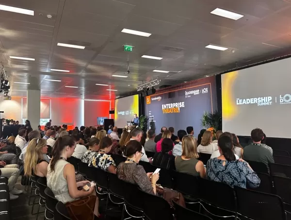 How AI LIVE: London Will Explore AI & Industrial Automation
The summit will convene C-suite executives from around the globe to address pressing challenges in global industries, ranging from AI-driven disruption to economic volatility.AI LIVE: The London Summit will gather over 2,000 international leaders und
How AI LIVE: London Will Explore AI & Industrial Automation
The summit will convene C-suite executives from around the globe to address pressing challenges in global industries, ranging from AI-driven disruption to economic volatility.AI LIVE: The London Summit will gather over 2,000 international leaders und

2026 Latest Best Top-rated AI Anomaly Detection Tools for KPI Monitoring in SaaS and Ecommerce teams! XIX.AI has curated a powerful, game-changing collection based on rigorous real-world tests and weekly updated rankings. You’ll find detailed free vs paid comparison insights to help you identify the must-try solution that boosts productivity and unlocks your AI edge. Explore now!
10 tools
xix.ai

2026 Latest Best Top-Rated AI Outline Generators for Long-Form SEO Articles, meticulously curated by XIX.AI. These powerful tools offer game-changing assistance in creating high-quality content quickly, boosting writing efficiency significantly. Get a free vs paid comparison along with real-world tests and detailed rankings to help you find the must-try option that suits your needs. Explore now to unlock your AI edge.
8 tools
xix.ai

2026 Latest Best AI Study Tools for Homework and Exam Prep! XIX.AI curates a top-rated list of powerful, game-changing tools that help students boost productivity, streamline homework completion, and ace exams through real-world tests. Get a free vs paid comparison, detailed rankings, and must-try options to unlock your AI edge. Explore now!
10 tools
xix.ai

2026 Latest Best AI Vocal Demo Tools for Songwriters, Hook Creators, and Multi-Language Content Teams! XIX.AI has curated a top-rated list of powerful game-changing tools that go through rigorous real-world tests. You’ll find detailed free vs paid comparison data, comprehensive rankings, and must-try options to help you boost writing efficiency and unlock your creative potential. Explore now to discover your perfect tool for all your content needs!
9 tools
xix.ai

2026 Latest Best Top-rated AI Competitive Research Tools for Small Businesses! XIX.AI has curated a highly powerful game-changing collection, updated weekly with rigorous real-world tests and detailed rankings. You can find a comprehensive free vs paid comparison to help you identify the must-try tools that boost your productivity and give you a competitive edge. Explore now to discover your perfect tool!
9 tools
xix.ai

2026 Latest Best Photoshop AI retouch tools for ecommerce apparel, skin cleanup, and color consistency! This top-rated curated list features powerful game-changing solutions that help you boost writing efficiency, streamline content creation, and achieve perfect visual results effortlessly. Each tool has undergone real-world tests through weekly updated rankings, complete with free vs paid comparison details. Backed by XIX.AI, it’s the must-try guide for anyone aiming to unlock your AI edge. Explore now!
10 tools
xix.ai